

Welcome to Ground Truth, OmniGeo’s publication on the intersection of geospatial AI and physical risk — for the people building in Earth observation and the underwriters, asset owners, and risk teams who have to trust them.
In Altadena this past January, the Eaton Fire left behind the image that has come to define the modern wildfire: one neighborhood reduced to ash, and right in the middle of it, seemingly untouched, a home that survived.
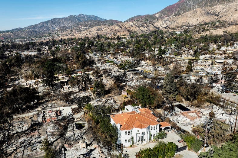
Now, it turns out, the difference between destruction and survival comes down to more than just luck. And we now have the data to prove it.
Over the past year, a remarkable run of research has converged on the same conclusion: the physical condition of an individual property, what the roof is made of, what’s growing in the first five feet, and whether the vents are screened, are the strongest determinants of whether that home survives. Home hardening and mitigation work, and the science behind it is now hard to argue with.
This raises a new question: if survival comes down to parcel-level physical detail, can we actually measure that detail at scale? Because most of the tools the industry relies on today cannot.
The 52% finding
The most rigorous evidence yet comes from a study led by UC Berkeley, published in Nature Communications in August 2025. Maryam Zamanialaei, Michael Gollner, and colleagues combined CAL FIRE’s ground-truth damage inspections from five of California’s most destructive fires (the 2017 Tubbs and Thomas, 2018 Camp, 2019 Kincade, and 2020 Glass fires) with physics-based fire and ember simulations across roughly 47,000 structures. A machine-learning model trained on the result predicted structure survival with 82% accuracy.
The headline finding is that hardening and defensible space, applied together, can dramatically reduce loss. In the study’s most aggressive scenario, which combined hardening the structure with clearing defensible space across the first 30 feet, modeled survival nearly doubled to 48%, and the authors summarize the combined effect as a “hypothetical 52% reduction in losses.”
“I view this as really powerful evidence that the mitigation measures that are available to us, hardening and defensible space, actually have some real-world effectiveness,” Gollner said, regarding their study. And on the limits of what we can control: “We can’t always change the spacing between structures or the exposure from flames and embers. But even within those limitations, we still have the power to cut the destruction in half, if not more. That is very powerful.”
The model also ranked what matters. Structure separation distance was the single strongest driver of loss, followed by exterior siding material, then year built, then flame exposure. The team found it was “most impactful to make changes both to the structure itself and surrounding fuels, especially vegetation and other flammable materials within 1.5m (5ft) of the structure.” Clearing that first five-foot zone alone, the contested “Zone 0,” could cut structure losses by 17%.
Note what every one of those variables has in common: siding material, roof construction, vent screens, vegetation within five feet. They are physical, material properties of a specific parcel.
From Survival Rates to Insurability
What the Berkeley team showed in physics, California’s regulators just translated into dollars. In March 2026, the California Department of Insurance and the NAIC released the first study to model how community-wide rebuilding to a hardening standard affects Average Annual Loss, the metric carriers lean on most heavily when deciding whether to write a policy at all.
Using Moody’s wildfire catastrophe model, they found that rebuilding the roughly 30,000 homes inside the Palisades and Eaton burn perimeters to the IBHS Wildfire Prepared Home standard would cut average losses by about a third (31% for the Base standard, 35% for Plus) at a marginal cost of roughly 3% per home. That is the difference, the Department argued, between a community stuck on the FAIR Plan and one a competitive private market will actually serve.
“Every home rebuilt to the Wildfire Prepared Home standard is a home that is safer for the family inside it, safer for its neighbors, and more likely to remain insurable for decades,” said Commissioner Ricardo Lara. Several of California’s largest carriers have now committed to writing policies for homes that earn the designation. Mitigation is no longer just a safety story; it has become an underwriting input.
What the Lab Confirms
The Insurance Institute for Business & Home Safety (IBHS) has spent more than a decade burning this question down to specifics in its research center. Their post-fire forensics and controlled ember tests keep pointing at the same culprits. Embers, not the flame front, are the leading cause of home ignition, and IBHS finds that an ember-resistant buffer in the first five feet can cut a home’s risk of igniting roughly in half.
“Time and time again in our post-fire analysis of the Los Angeles County wildfires, we saw the damage done by combustible items like plastic garbage cans right up against a home,” said Steve Hawks, IBHS Senior Director for Wildfire and a 30-year CAL FIRE veteran. “The bottom line based on the latest research is this: a limited area that is completely noncombustible prevents ember ignition.” Their checklist of what actually moves survival is short and concrete: a Class A fire-rated roof, ember-resistant vents, at least six inches of noncombustible material at the base of exterior walls, and a clear five-foot zone.
The Measurement Problem
So here is where the science runs into a wall. Every credible source above says the same thing: survival is decided by material, parcel-level facts, including roof composition, siding, vent type, the moisture and fuel of vegetation within feet of the wall, and whether mitigation has actually happened. Yet the dominant way the industry “sees” property risk today is aerial and satellite RGB imagery, and RGB has a fundamental blind spot, because it captures color and shape rather than material composition. A camera can make a best guess that a roof looks like tile, but it cannot tell you whether the roof is truly combustible, measure the moisture in the vegetation against the wall, or determine whether a vent is ember-resistant. It registers objects, while the physics that actually decides survival stays invisible to it.
The usual workaround is to train computer-vision models to label those objects, an expensive and brittle path. Building and labeling them costs millions, and as we wrote last time [insert link], even the most sophisticated foundation models degrade the moment the world shifts underneath them, whether that is a new region, a different sensor, a different season, or a post-event scene. Worst of all for this use case, aerial imagery is a snapshot, often a stale one, and it can’t price the thing the science says matters most: whether a property is more or less vulnerable after mitigation than it was before.
That is the gap. The science has settled whether parcel-level hardening works; what it has not solved is how to measure the physical condition of millions of homes accurately, by material, and over time. We started OmniGeo because that measurement problem, not another model, is the real bottleneck. Mitigation that no one can see can’t be priced, credited, or rewarded, and a home that can’t prove it’s been hardened won’t get the benefit of the doubt. And systematically rewarding mitigation is the key to a more resilient future and insurance ecosystem.
The measurement layer behind Ground Truth
OmniGeo’s first product, OmniFire, closes the earth measurement gap for insurers in wildfire-prone areas. OmniFire turns standard imagery into parcel-level measurements of what a property is actually made of, including roof material, defensible space, and fuel moisture. It’s vulnerability measured at scale and it’s live today. If you underwrite, price, or manage wildfire risk, visit www.omnigeo.ai/omnifire to learn more.